


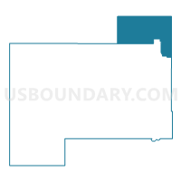
Voting District 231, Beckham County, Oklahoma
About
Outline

Summary
| Unique Area Identifier | 653504 |
| Name | Voting District 231 |
| County | Beckham County |
| State | Oklahoma |
| Area (square miles) | 76.37 |
| Land Area (square miles) | 75.92 |
| Water Area (square miles) | 0.45 |
| % of Land Area | 99.41 |
| % of Water Area | 0.59 |
| Latitude of the Internal Point | 35.45839700 |
| Longtitude of the Internal Point | -99.46129160 |
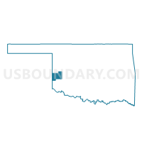
Maps

Graphs
Select a template below for downloading or customizing gragh for Voting District 231, Beckham County, Oklahoma


Neighbors
Neighoring Voting District (by Name) Neighboring Voting District on the Map
- Voting District 102, Roger Mills County, OK
- Voting District 14, Washita County, OK
- Voting District 201, Roger Mills County, OK
- Voting District 235, Beckham County, OK
- Voting District 26, Custer County, OK
- Voting District 332, Beckham County, OK
- Voting District 333, Beckham County, OK
Top 10 Neighboring County Subdivision (by Population) Neighboring County Subdivision on the Map
- Elk City CCD, Beckham County, OK (14,370)
- Northwest Washita CCD, Washita County, OK (4,018)
- Cheyenne CCD, Roger Mills County, OK (2,077)
- East Roger Mills CCD, Roger Mills County, OK (1,062)
- Butler CCD, Custer County, OK (1,046)
- South Roger Mills CCD, Roger Mills County, OK (508)
Top 10 Neighboring Place (by Population) Neighboring Place on the Map
Top 10 Neighboring Unified School District (by Population) Neighboring Unified School District on the Map
- Elk City Public Schools, OK (11,532)
- Merritt Public Schools, OK (3,360)
- Cheyenne Public Schools, OK (1,666)
- Canute Public Schools, OK (1,418)
- Hammon Public Schools, OK (1,124)
Top 10 Neighboring State Legislative District Lower Chamber (by Population) Neighboring State Legislative District Lower Chamber on the Map
- State House District 60, OK (36,383)
- State House District 57, OK (35,577)
- State House District 55, OK (35,481)
Top 10 Neighboring State Legislative District Upper Chamber (by Population) Neighboring State Legislative District Upper Chamber on the Map
Top 10 Neighboring 111th Congressional District (by Population) Neighboring 111th Congressional District on the Map
Top 10 Neighboring Census Tract (by Population) Neighboring Census Tract on the Map
- Census Tract 9661, Beckham County, OK (7,400)
- Census Tract 9662, Beckham County, OK (6,970)
- Census Tract 9649, Washita County, OK (4,018)
- Census Tract 9600, Roger Mills County, OK (3,647)
- Census Tract 9610, Custer County, OK (3,356)